
The Bab el-Mandeb Strait is one of the world’s most strategically significant waterways, linking the Red Sea to the Gulf of Aden and ultimately the vast Indian Ocean. Situated between the continents of Africa and Asia, this narrow maritime passage plays a crucial role in global trade, energy transportation, and geopolitical dynamics.
A detailed understanding of the Bab el-Mandeb Strait map helps illustrate why this region has long been a focal point for economic and strategic interests. On the map, the Bab el-Mandeb Strait appears as a narrow chokepoint separating the Arabian Peninsula from the Horn of Africa. To the northeast lies Yemen, while to the southwest are Djibouti and Eritrea.
- Exploring a Blank Map of Brazil
- Printable Blank World Map
- Blank World Map With Continents
- Printable Labeled Map of Asia
- Printable Blank Iran Map
- Blank Strait of Hormuz Map
Bab el-Mandeb Strait Map
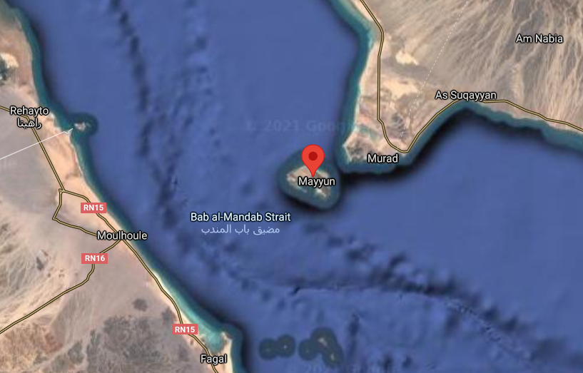
This positioning makes the strait a natural bridge between continents and a critical junction for maritime navigation. The width of the strait is approximately 20 miles (32 kilometers), but it is divided into two channels by Perim Island, which creates separate shipping lanes for vessels traveling in opposite directions.
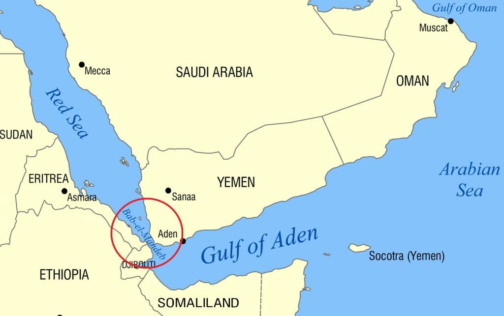
From a mapping perspective, the Bab el-Mandeb Strait is not just a geographical feature but a vital artery of global commerce. Ships traveling from Europe to Asia, or vice versa, frequently pass through the Suez Canal, then through the Red Sea, and finally the Bab el-Mandeb Strait before entering the Gulf of Aden and the Indian Ocean.
This route significantly reduces travel time compared to circumnavigating Africa via the Cape of Good Hope. As a result, the strait is heavily trafficked by cargo ships, oil tankers, and naval vessels.
Strait of Bab el Mandeb
The Bab el-Mandeb Strait map also highlights its importance in global energy supply chains. A substantial percentage of the world’s oil and liquefied natural gas shipments pass through this narrow passage. Disruptions in this region can have immediate and far-reaching effects on global markets, influencing fuel prices and supply stability.
This is one of the reasons why major world powers closely monitor the region and maintain a presence nearby. Geographically, the strait is divided into two main channels: the eastern channel, known as the Bab Iskender, and the western channel, called the Dact-el-Mayun.
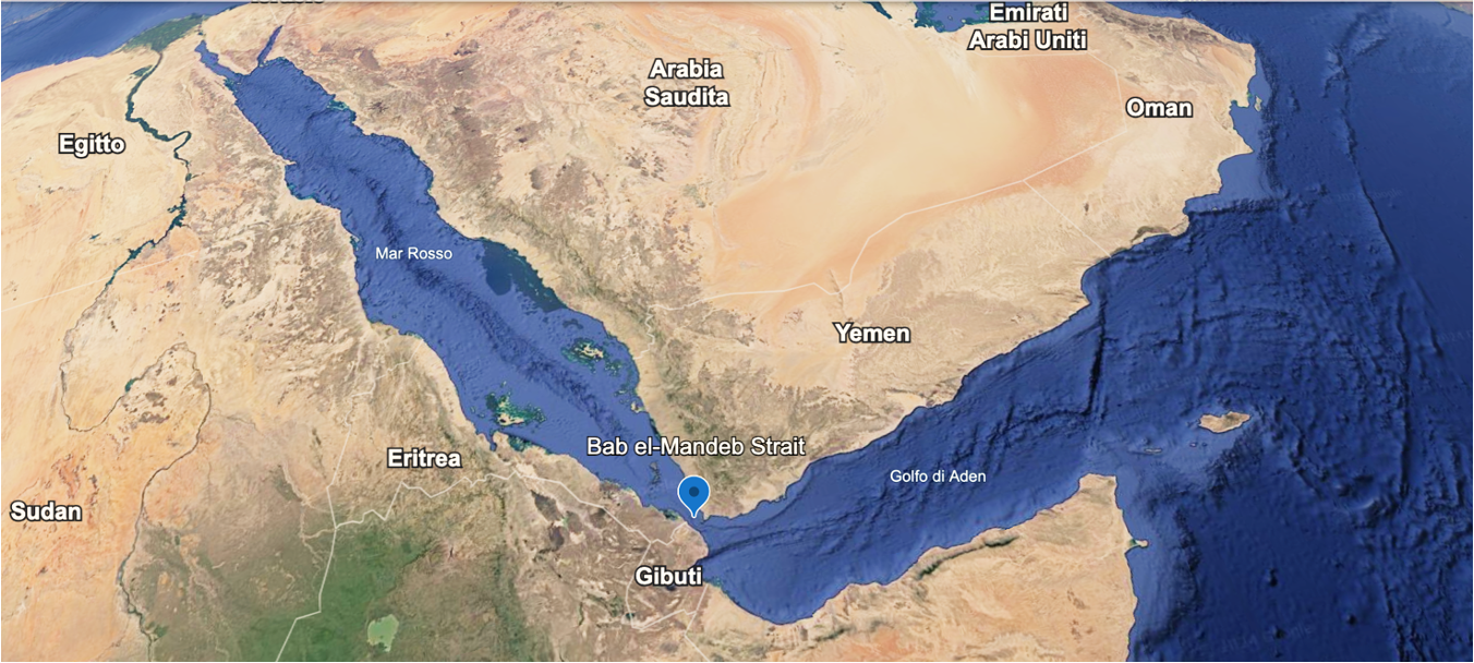
The eastern channel is narrower and shallower, while the western channel is wider and deeper, making it the preferred route for larger vessels. On most maps, these channels are clearly marked, providing navigational guidance for maritime traffic. The presence of Perim Island in the center of the strait further emphasizes the strategic complexity of the area.
Historically, the Bab el-Mandeb Strait has been a crossroads of civilizations and trade routes. Ancient traders used this passage to transport goods such as spices, textiles, and precious metals between Africa, the Middle East, and Asia.
Over time, the importance of the strait only increased, especially after the opening of the Suez Canal in 1869, which transformed global shipping patterns. Modern maps often include historical trade routes, demonstrating how this waterway has long been integral to economic exchange.
Location
Bab el Mandeb Strait Map
In addition to its economic significance, the Bab el-Mandeb Strait is also a region of geopolitical tension. Its proximity to conflict zones and politically sensitive areas makes it a hotspot for international security concerns. Naval patrols, anti-piracy operations, and international cooperation efforts are common in this region. The map often includes military bases and strategic points, highlighting the presence of global powers seeking to ensure the safety and stability of maritime routes.
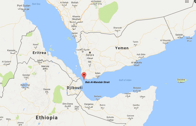
Environmental factors also play a role in shaping the Bab el-Mandeb Strait map. The region is influenced by seasonal winds, strong currents, and varying sea conditions, all of which affect navigation. Marine ecosystems in the area are rich and diverse, supporting fisheries and local livelihoods. However, increased shipping activity raises concerns about pollution and environmental degradation, making sustainable management an important consideration.
From a cartographic standpoint, modern Bab el-Mandeb Strait maps incorporate advanced technologies such as satellite imagery and digital navigation systems. These tools provide real-time data on ship movements, weather conditions, and potential hazards. Interactive maps used by shipping companies and maritime authorities offer detailed insights that go beyond traditional paper maps, enhancing safety and efficiency.
Bab al Mandab Strait
The economic significance of the Bab el-Mandeb Strait cannot be overstated. It serves as a gateway for trade between Europe, Asia, and Africa, facilitating the movement of goods worth billions of dollars each year. Ports in nearby regions, including those in Yemen and Djibouti, rely heavily on the traffic passing through the strait. Investments in infrastructure and port development further underscore the importance of this maritime corridor.
Understanding the Bab el-Mandeb Strait map also provides insight into global connectivity. It illustrates how a relatively small geographic feature can have a massive impact on international trade and relations. The strait acts as a link in a chain of critical waterways that include the Suez Canal and the Strait of Hormuz, forming a network that underpins the global economy.
Summary
In recent years, the Bab el-Mandeb Strait has gained even more attention due to shifting geopolitical dynamics and evolving trade patterns. As global demand for energy and goods continues to grow, the importance of secure and efficient shipping routes becomes increasingly vital. The map of the strait serves as a visual reminder of its central role in connecting distant regions and facilitating economic activity.
Frequently Asked Questions (FAQs)
What is the Bab el-Mandeb Strait, and where is it located?
The Bab el-Mandeb Strait is a narrow waterway that connects the Red Sea to the Gulf of Aden. It is located between Yemen on the Arabian Peninsula and Djibouti and Eritrea in Africa.
Where Is The Bab El-Mandeb Strait?
The Bab el-Mandeb Strait is a narrow waterway located between Africa and Asia, connecting the Red Sea to the Gulf of Aden and the Indian Ocean.
It lies between Yemen on the Asian side and Djibouti and Eritrea on the African side. Positioned at the southern end of the Red Sea, it serves as a vital global shipping route linking Europe, Asia, and Africa.
Why is the Bab el-Mandeb Strait important?
It is crucial for global trade and energy transportation, as a large volume of oil and goods passes through it every day. It also serves as a key link between Europe and Asia.
How wide is the Bab el-Mandeb Strait?
The strait is approximately 20 miles (32 kilometers) wide at its narrowest point and is divided into two channels by Perim Island.
What role does the Bab el-Mandeb Strait play in global shipping?
It acts as a major transit route for ships traveling between the Mediterranean Sea via the Suez Canal and the Indian Ocean, significantly reducing travel time.
Are there any risks associated with the Bab el-Mandeb Strait?
Yes, the region faces challenges such as geopolitical tensions, piracy, and environmental concerns, all of which can impact shipping and trade.
How does the Bab el-Mandeb Strait affect global oil supply?
A significant portion of the world’s oil shipments passes through the strait, making it a critical point in the global energy supply chain. Any disruption can influence oil prices worldwide.
What countries border the Bab el-Mandeb Strait?
The Bab el-Mandeb Strait map ultimately reveals much more than a simple geographic feature; it tells the story of global trade, strategic importance, and the interconnected nature of our world. Understanding this map provides valuable insight into how geography continues to shape economics, politics, and international relations.