Iran, officially known as the Islamic Republic of Iran, is a vast and geographically diverse country located in West Asia. A labeled map of Iran with states, cities, and the capital provides a comprehensive understanding of how the country is divided administratively and geographically.
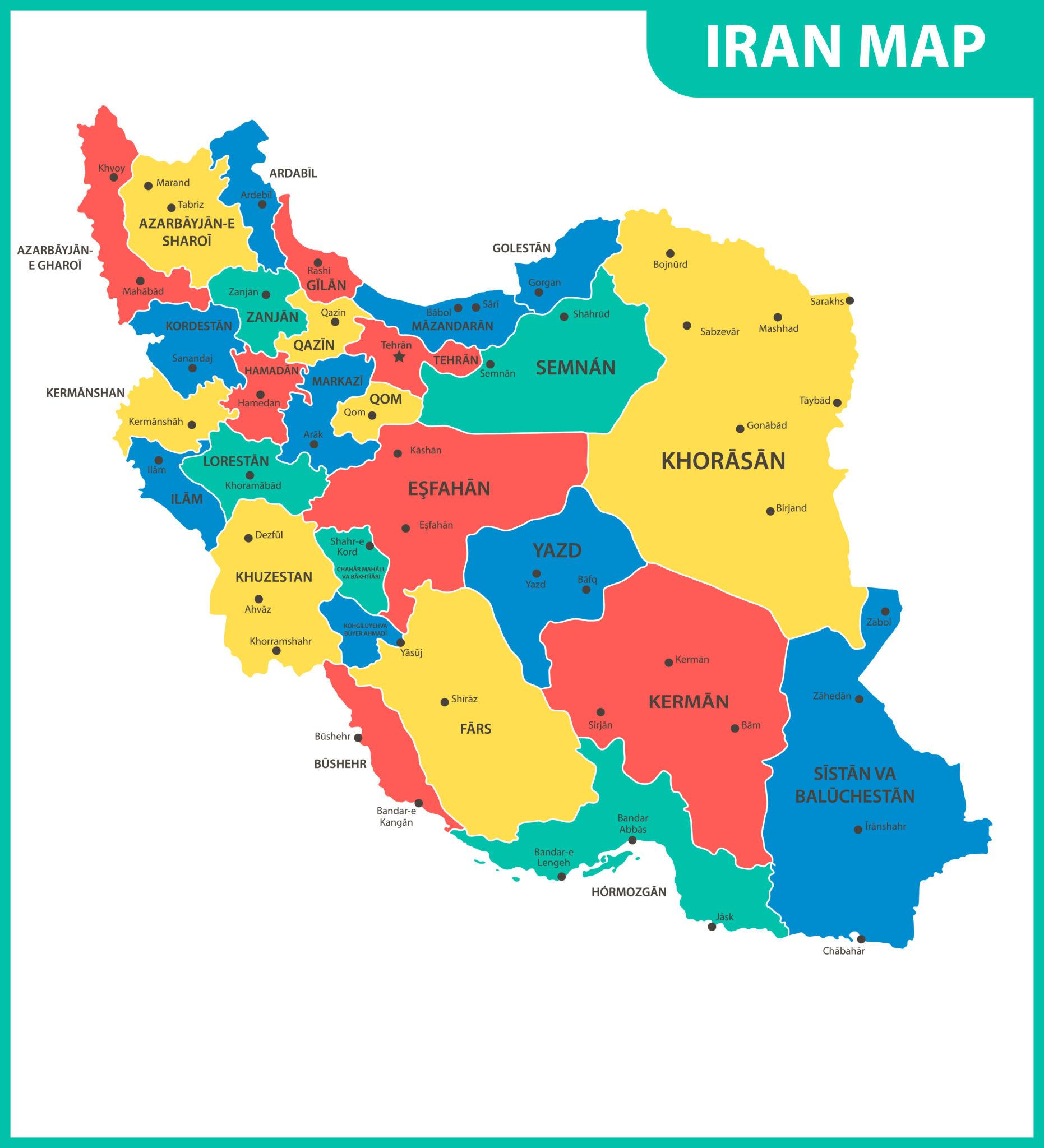
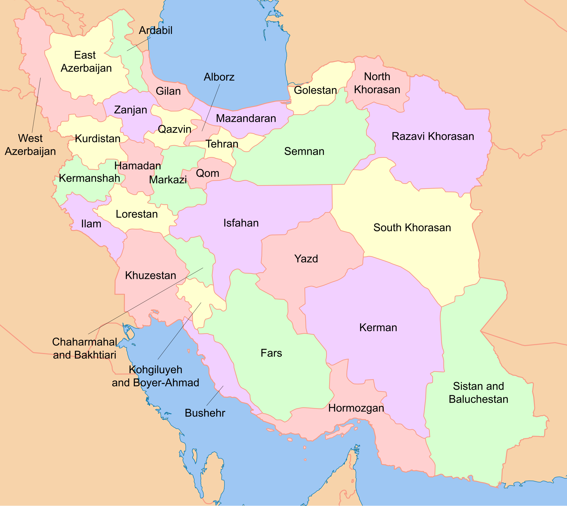
Iran is divided into 31 provinces, each functioning as a state-like administrative unit governed from its own capital city. These provinces are further divided into counties, districts, and local municipalities, forming a structured administrative system that supports governance, economic development, and regional planning.
- Exploring a Blank Map of Brazil
- Printable Blank World Map
- Blank World Map With Continents
- Printable Labeled Map of Asia
- Printable Blank Iran Map
- Blank Strait of Hormuz Map
Labeled Map of Iran
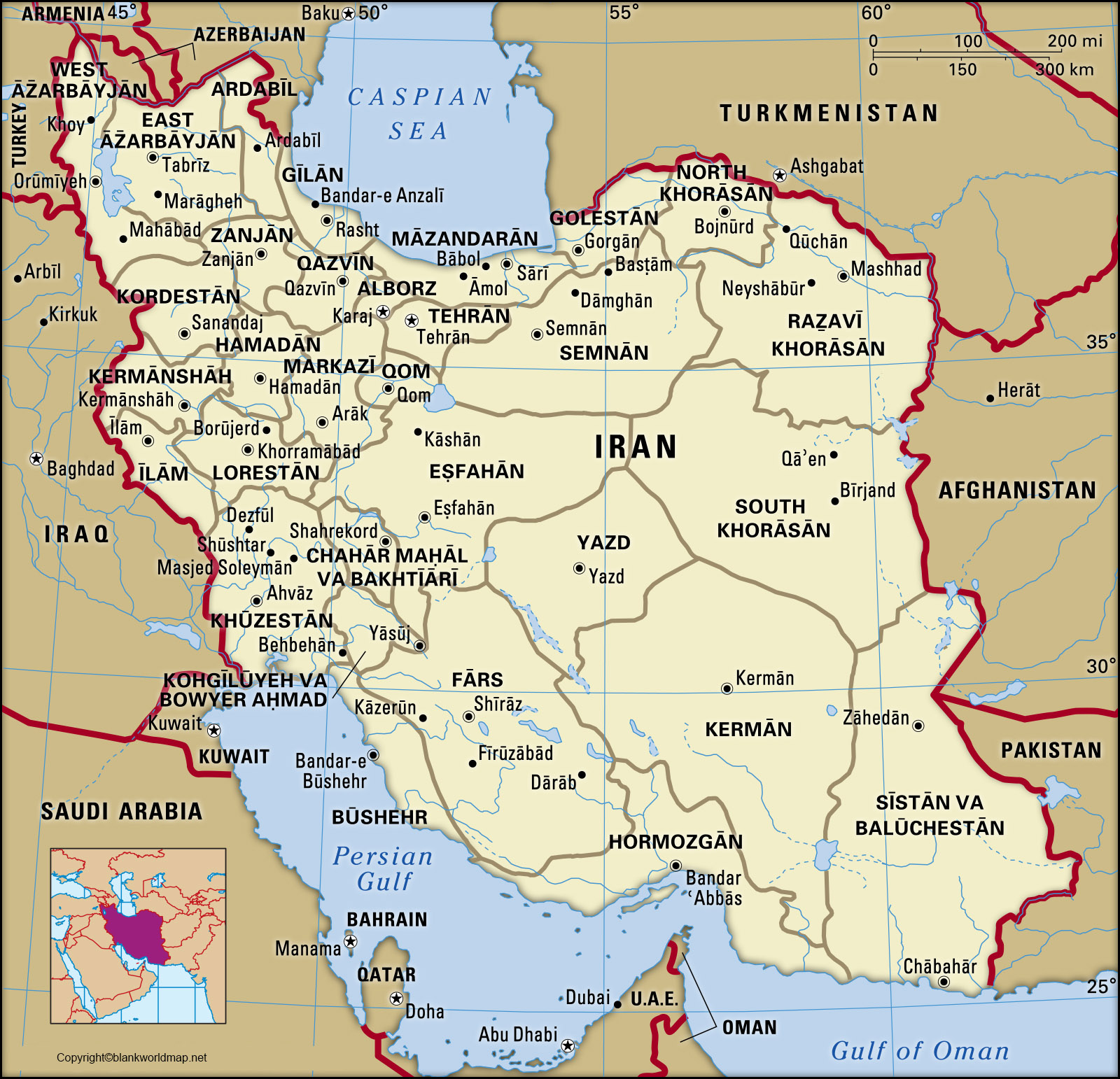
The capital city of Iran is Tehran, which is not only the political center but also the largest and most populous city in the country. Located in the northern part of Iran, Tehran serves as the hub of administration, commerce, and culture. On a labeled map, Tehran is prominently marked due to its importance as the national capital and its dense urban population.
Each province in Iran has its own capital city, which is usually the largest urban center in that region. For example, Alborz Province has Karaj as its capital, while East Azerbaijan is governed from Tabriz. Similarly, Fars Province is centered around Shiraz, and Isfahan Province is anchored by the historic city of Isfahan.
These cities are significant not only administratively but also historically and culturally, making them key highlights on any labeled map of Iran. Iran’s provinces are distributed across different geographic regions, each with unique characteristics. The northern provinces, such as Gilan and Mazandaran, lie along the Caspian Sea and are known for their lush greenery and humid climate.
Cities like Rasht and Sari are major urban centers in these regions. In contrast, central provinces like Yazd and Qom are characterized by arid desert landscapes, with cities such as Yazd and Qom representing historical and religious importance.
Labeled Map of Iran with States
Western Iran includes provinces like Kermanshah, Kurdistan, and Ilam, which are closer to the border with Iraq. These regions feature mountainous terrain and culturally diverse populations. Cities such as Kermanshah and Sanandaj play important roles in regional trade and cultural exchange. Meanwhile, southern provinces like Hormozgan and Bushehr are located along the Persian Gulf, with Bandar Abbas and Bushehr serving as major port cities.
Eastern Iran consists of provinces like Sistan and Baluchestan and South Khorasan, where cities such as Zahedan and Birjand are important administrative centers. These regions are known for their desert landscapes and strategic proximity to neighboring countries like Pakistan and Afghanistan.
A labeled map of Iran also highlights major metropolitan cities that go beyond provincial capitals. Mashhad, located in Razavi Khorasan Province, is one of the largest cities and a major religious center. Isfahan is known for its architectural beauty and historical significance, while Tabriz in the northwest is an important industrial and cultural hub.
Other notable cities include Ahvaz in Khuzestan, Karaj in Alborz, and Shiraz in Fars, each contributing significantly to Iran’s economy and heritage. Understanding the labeled map of Iran requires attention to both political boundaries and physical geography.
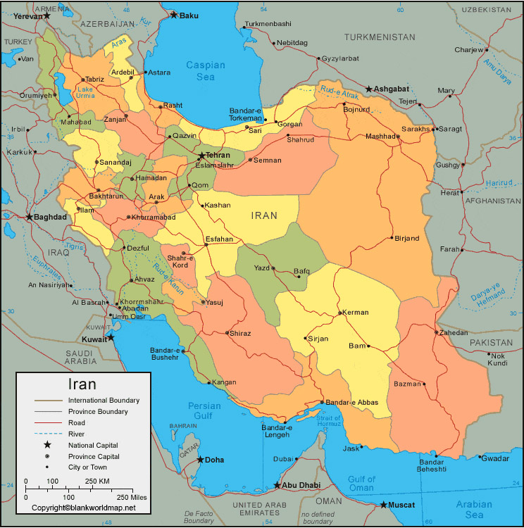
The country is largely situated on the Iranian plateau and is surrounded by mountain ranges such as the Zagros Mountains, which run from the northwest to the southeast. These natural features influence settlement patterns, transportation routes, and economic activities. Many cities are located in basins surrounded by mountains, which historically led to the development of distinct cultural and economic regions.
Labeled Map of Iran with the Capital
Iran’s administrative structure ensures that each province operates with a degree of autonomy under the supervision of the central government. Provincial capitals serve as administrative headquarters where local governance is managed. This system allows for efficient management of resources, infrastructure, and public services across diverse geographic areas.
A detailed labeled map also shows the interconnection between provinces through major highways and transportation networks. Cities like Tehran, Isfahan, and Mashhad are connected through extensive road and rail systems, facilitating trade and travel. These connections are essential for economic integration and national development.
In addition to administrative importance, many cities marked on the map are also tourist destinations. Shiraz is famous for its poetry and gardens, Isfahan for its historic squares and mosques, and Yazd for its unique desert architecture. Coastal cities like Bandar Abbas attract visitors with their maritime culture and scenic views.
Iran Map with Cities Labeled
The significance of a labeled map of Iran extends beyond geography; it also reflects the country’s cultural diversity. Each province has its own traditions, languages, and customs, contributing to Iran’s rich cultural mosaic. For instance, Kurdish communities are prominent in western provinces, while Balochi culture is prevalent in the southeast.
From an educational perspective, a labeled map of Iran is an essential tool for students, researchers, and travelers. It helps in understanding the spatial distribution of cities, the location of provinces, and the relationship between different regions. Whether for academic study or travel planning, such a map provides valuable insights into the country’s structure and organization.
Conclusion
In conclusion, a labeled map of Iran with states, cities, and the capital offers a detailed overview of one of the most historically rich and geographically diverse countries in the world. By identifying provinces, highlighting major cities, and marking the capital, the map serves as a comprehensive guide to understanding Iran’s administrative and geographic landscape. It is a valuable resource for anyone interested in geography, travel, or cultural studies.
FAQs
1. How Many States or Provinces are there in Iran?
Iran has 31 provinces, each serving as a primary administrative division of the country.
2. What is the Capital of Iran?
The capital of Iran is Tehran, which is also the largest city in the country.
3. Which are the Major Cities in Iran?
Major cities include Tehran, Mashhad, Isfahan, Tabriz, Shiraz, and Ahvaz, all of which are important economic and cultural centers.
4. What is the Purpose of a Labeled Map of Iran?
A labeled map helps identify provinces, cities, and geographic features, making it useful for education, travel, and research.
5. Are Provinces and States the same in Iran?
Yes, provinces in Iran function similarly to states in other countries, each having its own capital and local administration.